


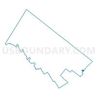
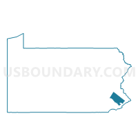
ROCKLEDGE Voting District, Montgomery County, Pennsylvania
About
Outline

Summary
| Unique Area Identifier | 661502 |
| Name | ROCKLEDGE Voting District |
| County | Montgomery County |
| State | Pennsylvania |
| Area (square miles) | 0.35 |
| Land Area (square miles) | 0.35 |
| Water Area (square miles) | 0.00 |
| % of Land Area | 100.00 |
| % of Water Area | 0.00 |
| Latitude of the Internal Point | 40.08222190 |
| Longtitude of the Internal Point | -75.08981040 |
Maps

Graphs
Select a template below for downloading or customizing gragh for ROCKLEDGE Voting District, Montgomery County, Pennsylvania


Neighbors
Neighoring Voting District (by Name) Neighboring Voting District on the Map
- ABINGTON TWP WD 02 DIST 01, Montgomery County, PA
- ABINGTON TWP WD 03 DIST 01, Montgomery County, PA
- ABINGTON TWP WD 03 DIST 02, Montgomery County, PA
- ABINGTON TWP WD 04 DIST 01, Montgomery County, PA
- PHILADELPHIA WD 63 PCT 01, Philadelphia County, PA
- PHILADELPHIA WD 63 PCT 02, Philadelphia County, PA
- PHILADELPHIA WD 63 PCT 11, Philadelphia County, PA
- PHILADELPHIA WD 63 PCT 14, Philadelphia County, PA
Top 10 Neighboring County Subdivision (by Population) Neighboring County Subdivision on the Map
- Philadelphia city, Philadelphia County, PA (1,526,006)
- Abington township, Montgomery County, PA (55,310)
- Rockledge borough, Montgomery County, PA (2,543)
Top 10 Neighboring Place (by Population) Neighboring Place on the Map
Top 10 Neighboring Unified School District (by Population) Neighboring Unified School District on the Map
Top 10 Neighboring State Legislative District Lower Chamber (by Population) Neighboring State Legislative District Lower Chamber on the Map
- State House District 172, PA (61,906)
- State House District 170, PA (60,573)
- State House District 153, PA (58,809)
Top 10 Neighboring State Legislative District Upper Chamber (by Population) Neighboring State Legislative District Upper Chamber on the Map
Top 10 Neighboring 111th Congressional District (by Population) Neighboring 111th Congressional District on the Map
Top 10 Neighboring Census Tract (by Population) Neighboring Census Tract on the Map
- Census Tract 2019.02, Montgomery County, PA (5,968)
- Census Tract 341, Philadelphia County, PA (5,577)
- Census Tract 2019.01, Montgomery County, PA (4,725)
- Census Tract 342, Philadelphia County, PA (3,399)
- Census Tract 339, Philadelphia County, PA (2,924)
- Census Tract 2020, Montgomery County, PA (2,543)